Middle section : Before (2023) & After (2023), work done 2023
Location
Borrowdale, south east of Derwent Water
Legal status
Public Right of Way footpath
Path use
A popular access route to the Derwent Fells and the various high level routes around the Newlands Valley.
Historic interest
There is an old quarry road leading down from the quarries. This road was well maintained until the 1940s.
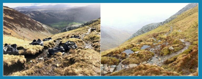
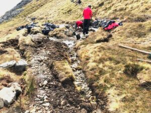
The middle section from below, showing the braiding and damage to the peat
The problem
Work done in 2023 addressed issues on three sections of the path. The top section, just below the stile, was badly gullied and eroded. The middle section, just below the top section, runs through peat and can get very wet, so people spread out to try to find a drier line. This causes braiding of the path and damage to the peat through washing out of the peat hags and subsequent drying out of the peat. Lower down, on the steeper sections, large amounts of water flow down the path after heavy rain, eroding the soil, causing the pitching to fall out and side gullies to be created.
Repair techniques
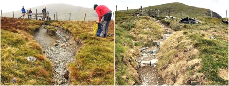
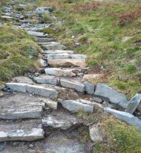
On the top section, the path immediately below the stile was pitched and a series of stone risers installed to reduce the gradient and therefore the power of any water on the path. The turf banks were graded and collapsed down to improve their resilience.
New pitching and risers installed just below the stile
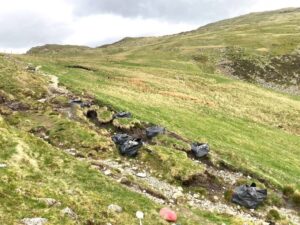
On the middle section (see the photos on the first page), it was important that the path remains dry (and hence attractive to walkers) whilst retaining moisture within the peat nearby. A new path line was created to the right of the eroded section with a cross drain and a wath to carry the water into the peaty area. Leaky dams were constructed in this area, using a combination of rocks, soil and turf. Water is consequently held up, only slowly filtering through, creating pools and restoring the moisture back into the peat and increasing the vegetation cover.
Constructing the new path line before damming the areas of peat run-off
New pitching and the start of the drain which takes the water into Tongue Gill
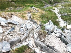
The third site was a bit lower down, on some of the steeper sections. There was a significant erosion scar here and it was important to tackle it due to the surrounding rich ecological communities. Wide areas of exposed soil and loose material meant the site was very vulnerable to gullying. New pitching was installed to provide a sustainable surface. Drainage features were used to manage the large volumes of water. A cross drain was constructed to take the water off the path. This then feeds into a long drain cutting across the fell and into Tongue Gill.
The erosion scar has been largely eradicated through a considerable emphasis on sensitive landscaping to complement the pitching, drainage and line definition.
One option was to take a more direct line to the gill but this would have meant cutting through the bank of soil (to the left in the photo opposite). However, it was felt that this would have negatively impacted the landscape and look unnatural. Instead, a long drain was constructed below the mound. The drain, constructed through the loose piles of mobile quarry waste, has a definite industrial feel which is in keeping with the surrounding landscape.
Looking down showing the full extent of the drain to Tongue Gill. Path on the right of photo.
This path improvement work was undertaken mainly during 2023 and took 179 ranger days, costing around £36k, and 33 volunteer days.